The commercial drone industry is rapidly transforming various sectors, from logistics and healthcare to emergency services and urban planning. With the potential to revolutionize how cities and businesses operate, drones are becoming an essential part of the “New Aerial Economy” – a future where aerial vehicles will play a key role in transportation, deliveries, and infrastructure management. However, as drones take to the skies in increasing numbers, cities, states, and countries are tasked with understanding and navigating complex regulation and compliance challenges.
Managing drones’ safe, efficient, and scalable use requires robust regulations that address everything from airspace management to public safety, privacy concerns, and environmental impact. At the same time, local governments and private organizations must ensure compliance with these regulations, balancing innovation with safety and security.
HoverSafe’s Software-as-a-Service (SaaS) solution offers cities the tools to streamline the regulatory process, ensure compliance with local, state, and federal laws, and optimize drone operations for efficiency and sustainability. By embracing these solutions, cities can successfully navigate the challenges of commercial drone regulation and unlock the full potential of the New Aerial Economy.
Airspace Management and Flight Path Regulation
Managing airspace is one of commercial drone operators’ most significant regulatory challenges. As the skies become increasingly crowded with unmanned aerial vehicles (UAVs), cities must establish clear rules for where and when drones can fly. This is particularly important in urban environments where high-rise buildings, power lines, and densely populated areas create unique safety hazards.
Defining No-Fly Zones
Cities and regulators must identify sensitive areas where drones are prohibited from flying. These no-fly zones often include airports, government buildings, military installations, and certain residential areas. Ensuring that drones comply with these restrictions is crucial for maintaining public safety and preventing accidents.
Additionally, cities may need to create temporary no-fly zones in response to public gatherings, parades, or emergencies. For example, drones may need to be grounded during a natural disaster or large-scale public event to avoid interfering with emergency response teams or causing security concerns.
Designating Safe Drone Corridors
While no-fly zones are critical for safety, cities must also designate drone corridors – predefined flight paths that drones can use for delivery or transport operations. These corridors allow for safe, regulated movement of drones while minimizing their impact on urban life. Corridors should be designed to avoid areas where drones could pose a risk to public safety, such as densely populated neighborhoods while ensuring they are accessible for essential services like medical deliveries or emergency response.
Platforms like HoverSafe provide city managers with the tools to create and manage these drone corridors. Using real-time data, HoverSafe can help cities monitor drone traffic and ensure that all flight paths comply with local airspace regulations.
Zoning and Permitting for Drone Infrastructure
Cities must build the necessary infrastructure to support the growing commercial drone industry, such as vertiports, recharging stations, and emergency landing zones. However, constructing these facilities presents a significant regulatory challenge, as they must comply with local zoning laws, safety standards, and environmental regulations.
Navigating Zoning Laws for Drone Infrastructure
Zoning laws regulate land use within a city, dictating where certain activities can occur. In urban areas, vertiports may be integrated into rooftops of commercial buildings or parking garages, while recharging stations could be placed near distribution centers. Cities must carefully consider the impact of these facilities on local communities, ensuring they do not interfere with existing businesses or residential areas.
HoverSafe’s software platform simplifies the zoning and permitting process by helping city officials manage the logistics of drone infrastructure development. From processing permits to tracking inspections, HoverSafe ensures that all drone facilities meet regulatory requirements while maintaining operational efficiency.
Permitting and Compliance for Drone Operations
In addition to zoning, cities must establish permitting processes for businesses and individuals operating commercial drones. These permits ensure drone operators comply with safety standards, follow designated flight paths, and adhere to noise restrictions. The permitting process can be complex, involving multiple levels of government oversight. It can vary significantly depending on the type of drone operation—whether it’s for delivery services, infrastructure inspections, or emergency response.
HoverSafe provides tools to streamline this permitting process, enabling cities to issue and manage permits efficiently. The platform also tracks compliance, ensuring drone operators follow all local regulations and safety protocols.
Addressing Privacy and Data Security Concerns
As commercial drones become more prevalent, public privacy and data security concerns will inevitably grow. Drones equipped with cameras, sensors, and data-gathering technology can capture images and information from private properties, raising fears about surveillance and the misuse of personal data.
Implementing Privacy Protections
Cities and businesses must develop clear privacy policies that protect citizens from unwanted surveillance. Regulations should specify where drones are allowed to capture images or data and the purposes for which this data can be used. For example, drones used for infrastructure inspections or environmental monitoring may need special permissions to fly over private property, and the data collected must be securely stored to prevent unauthorized access.
HoverSafe helps cities enforce these privacy protections by providing tools that allow city managers to monitor drone activity in real-time. The platform can ensure that drones respect privacy zones, such as residential areas, schools, and hospitals, and that any data collected complies with local privacy laws.
Noise Control and Environmental Impact
As drones become more common in urban environments, managing their environmental impact, particularly in terms of noise pollution, is becoming a pressing concern. Unlike traditional vehicles, drones operate at low altitudes and can be disruptive to residents if not properly regulated.
Implementing Noise Control Regulations
Cities must set clear guidelines for noise levels that drones are allowed to produce, particularly in residential areas. These regulations may include restrictions on the hours when drones can operate or limits on the number of drones in a given area. Failure to address noise pollution can lead to public backlash and hinder the adoption of commercial drone operations.
HoverSafe allows cities to manage drone noise levels by providing real-time monitoring of drone operations. The platform enables city managers to track compliance with noise regulations and take corrective action if necessary.
Minimizing Environmental Impact
In addition to noise control, cities must also consider the broader environmental impact of drone operations, including their energy consumption and carbon footprint. Many commercial drones are powered by electricity, offering a cleaner alternative to traditional fossil-fuel-powered vehicles. However, cities must ensure that drone infrastructure, such as recharging stations, is built and maintained in an environmentally sustainable way.
HoverSafe supports cities in implementing environmentally friendly practices by offering tools to monitor and optimize drone operations’ energy efficiency. By integrating renewable energy sources, such as solar-powered recharging stations, cities can further reduce drone operations’ environmental impact.
Ensuring Public Safety and Emergency Preparedness
As drones become more integrated into urban life, ensuring public safety remains a top priority. Cities must be prepared to manage drone accidents, malfunctions, and potential conflicts with manned aircraft.
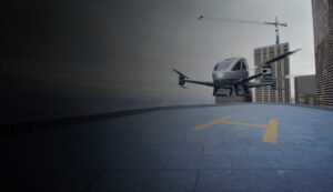
Establishing Emergency Landing Zones
In the event of a drone malfunction or emergency, cities must have designated emergency landing zones where drones can safely land without harming people or property. These zones must be strategically placed throughout urban areas and regularly inspected to ensure they are always operational.
HoverSafe’s platform helps cities manage these emergency landing zones by providing real-time monitoring and inspection tools. The platform ensures that landing zones are always ready for use and that drone operators can quickly access them in an emergency.